Dissertation
After the common portion of sweat and pain, I finished my dissertation in 2018. It was part of the DFG-funded CAOS Project (short for “Catchments as orgnised Systems”) and conducted at the Helmholtz-Centre for Geosciences in Potsdam. It also included extensive field work in Luxembourg and a DAAD-funded research stay at Duke University (USA) in the working group of Brian McGlynn. My Alma Mater is the University of Potsdam.
View or download the whole thing here, or enjoy the short ride:
Summary
The concept of hydrologic connectivity summarizes all flow processes that link separate regions of a landscape. As such, it is a central theme in the field of catchment hydrology, with influence on neighboring disciplines such as ecology and geomorphology. It is widely acknowledged to be an important key in understanding the response behavior of a catchment and has at the same time inspired research on internal processes over a broad range of scales. From this process-hydrological point of view, hydrological connectivity is the conceptual framework to link local observations across space and scales.
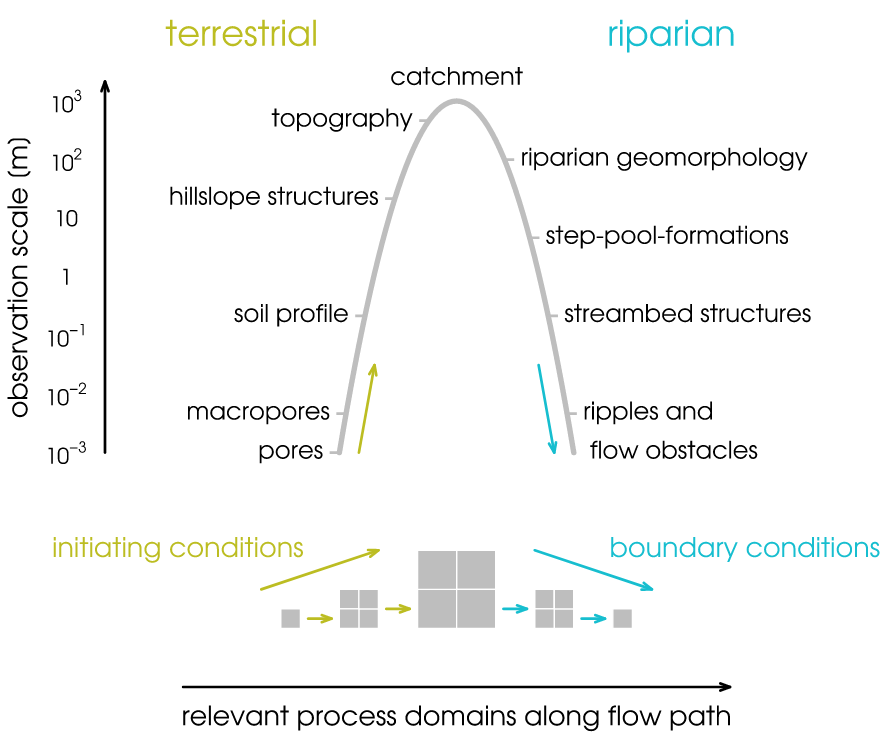
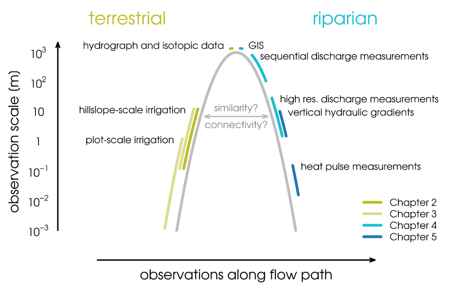
This is the context in which the four studies this thesis comprises of were conducted. The focus was on structures and their spatial organization as important control on preferential subsurface flow. Each experiment covered a part of the conceptualized flow path from hillslopes to the stream: soil profile, hillslope, riparian zone, and stream.
For each study site, the most characteristic structures of the investigated domainand scale, such as slope deposits and peat layers were identified based on preliminary or previous investigations or literature reviews. Additionally, further structural data was collected and topographical analyses were carried out. Flow processes were observed either based on response observations (soil moisture changes or discharge patterns) or direct measurement (advective heat transport). Based on these data,the flow-relevance of the characteristic structures was evaluated, especially with regard to hillslope to stream connectivity.
Results of the four studies revealed a clear relationship between characteristic spatial structures and the hydrological behavior of the catchment. Especially the spatial distribution of structures throughout the study domain and their interconnectedness were crucial for the establishment of preferential flow paths and their relevance for large-scale processes. Plot and hillslope-scale irrigation experiments showed that the macropores of a heterogeneous, skeletal soil enabled preferential flow paths at the scale of centimeters through the otherwise unsaturated soil. These flow paths connected throughout the soil column and across the hillslope and facilitated substantial amounts of vertical and lateral flow through periglacial slope deposits.
In the riparian zone of the same headwater catchment, the connectivity between hillslopes and stream was controlled by topography and the dualism between characteristic subsurface structures and the geomorphological heterogeneity of the stream channel. At the small scale (1 m to 10 m) highest gains always occurred at steps along the longitudinal streambed profile, which also controlled discharge patterns at the large scale (100 m) during base flow conditions (number of steps per section). During medium and high flow conditions, however, the impact of topography and parafluvial flow through riparian zone structures prevailed and dominated the large scale response patterns.
In the streambed of a lowland river, low permeability peat layers affected the connectivity between surface water and groundwater, but also between surface water and the hyporheic zone. The crucial factor was not the permeability of the streambed itself, but rather the spatial arrangement of flow-impeding peat layers, causing increased vertical flow through narrow “windows” in contrast to predominantly lateral flow in extended areas of high hydraulic conductivity sediments.
These results show that the spatial organization of structures was an important control for hydrological processes at all scales and study areas. In a final step, the observations from different scales and catchment elements were put in relation and compared. The main focus was on the theoretical analysis of the scale hierarchies of structures and processes and the direction of causal dependencies in this context. Based on the resulting hierarchical structure, a conceptual framework was developed which is capable of representing the system’s complexity while allowing for adequate simplifications.
The resulting concept of the parabolic scale series is based on the insight that flow processes in the terrestrial part of the catchment (soil and hillslopes) converge. This means that small-scale processes assemble and form large-scale processes and responses. Processes in the riparian zone and the streambed, however, are not well represented by the idea of convergence. Here, the large-scale catchment signal arrives and is modified by structures in the riparian zone, stream morphology, and the small-scale interactions between surface water and groundwater. Flow paths diverge and processes can better be represented by proceeding from large scales to smaller ones. The catchment-scale representation of processes and structures is thus the conceptual link between terrestrial hillslope processes and processes in the riparian corridor.